Arsip:

GNSS Trimble R8s

Pengambilan data point cloud menggunakan TLS oleh Marcelinus Palma Surya Valendra bersama tiga mahasiswa lainnya di Stasiun Palbapang, Bantul

Integrating TLS and GNSS, Sekolah Vokasi UGM Students Map 3D Model of Palbapang Station in Bantul

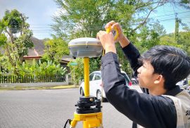
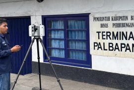
Bantul, April 7, 2026 — Students of the Applied Bachelor Program in Surveying and Mapping Technology, Sekolah Vokasi, Universitas Gadjah Mada, conducted Terrestrial Laser Scanner (TLS) and Global Navigation Satellite System (GNSS) data acquisition as part of their research activities. The activity took place on April 6–7, 2026, at Palbapang Station, Bantul.

Penggunaan alat Trimble R8s pada kegiatan Praktikum GNSS oleh mahasiswa Teknologi Survei dan Pemetaan Dasar

Enhancing Basic Mapping Competencies, SV UGM Applied Undergraduate Program Conducts GNSS Data Processing Practicum

The GNSS practicum was a mandatory academic activity for students of the Applied Bachelor Program in Surveying and Mapping Technology Universitas Gadjah Mada Vocational College (SV UGM). Conducted within the UGM campus on March 4, 5, and 12, 2026, the practicum aimed to provide students with hands-on experience in GNSS operation, data acquisition, and data processing using static, RTK NTRIP, and PPK methods with Trimble R8s equipment. The practicum involved 61 students and was supervised by the course lecturer as part of practice-based learning.