Arsip:

SDG Sustainable Cities and Communities

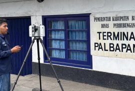
Pengambilan data point cloud menggunakan TLS oleh Marcelinus Palma Surya Valendra bersama tiga mahasiswa lainnya di Stasiun Palbapang, Bantul

Integrating TLS and GNSS, Sekolah Vokasi UGM Students Map 3D Model of Palbapang Station in Bantul

Bantul, April 7, 2026 — Students of the Applied Bachelor Program in Surveying and Mapping Technology, Sekolah Vokasi, Universitas Gadjah Mada, conducted Terrestrial Laser Scanner (TLS) and Global Navigation Satellite System (GNSS) data acquisition as part of their research activities. The activity took place on April 6–7, 2026, at Palbapang Station, Bantul.

Penyerahan training kit pelatihan dari Academy of Spatial & BIM kepada CoE Smart and Green Building Information Sekolah Vokasi Universitas Gadjah Mada yang diwakili oleh Dr. Anindya Sricandra Prasidya, S.T., M.Eng. (Dosen Departemen Teknologi Kebumian)

Enhancing Digital Construction Competency, CoE Smart & Green Building Sekolah Vokasi UGM Holds BIM Road Infrastructure Training

The Center of Excellence (CoE) Smart & Green Building Information at Universitas Gadjah Mada  Sekolah Vokasi UGM successfully organized a Building Information Modeling (BIM) training on road infrastructure on January 27 and 29, 2026. The activity was held in Room 504 of the Teaching Industry Learning Center (TILC) Building,  Sekolah Vokasi UGM. The training was attended by five participants from various groups within the  Sekolah Vokasi UGM, including students, academic staff, and lecturers from the Department of Earth Technology and the Department of Civil Engineering. The program aimed to enhance participants’ understanding and skills in applying BIM technology for road infrastructure planning and modeling.