Arsip:

surveying and mapping

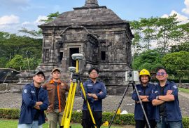
Dokumentasi kegiatan akuisisi data oleh tim di Candi Banyunibo dengan TLS dan GNSS

SV UGM Students Conduct 3D Modeling of Banyunibo Temple for Cultural Heritage Digital Documentation

Sleman — Students from the Department of Geomatics Engineering at the Universitas Gadjah Mada Vocational College (SV UGM) conducted a data acquisition activity as part of their final project titled “3D Modeling of Banyunibo Temple Based on the Integration of Terrestrial Laser Scanner and UAV Photogrammetry for Digital Documentation.” The activity was carried out on 25–26 April 2026 at Banyunibo Temple, Prambanan, Sleman, Special Region of Yogyakarta .
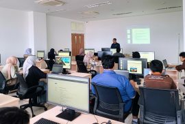
Mahasiswa Program Studi Sarjana Terapan Teknologi Survei dan Pemetaan Dasar Sekolah Vokasi UGM mengikuti Praktikum Survei Fotogrametri Terestrial di Ruang 504 CoE Smart and Green Building Information, dengan fokus pada pengolahan data dan pemodelan 3D berbasis perangkat lunak fotogrametri

Sekolah Vokasi UGM Photogrammetry Practicum: Producing Reliable Graduates in Digital Mapping

Yogyakarta — Students of the Applied Bachelor Program in Surveying and Mapping Technology, Sekolah Vokasi Universitas Gadjah Mada, conducted the Class A Terrestrial Photogrammetry Practicum on Wednesday, March 11, 2026. The activity took place in Room 504 of the Center of Excellence Smart and Green Building Information, Teaching Industry Learning Center Building.